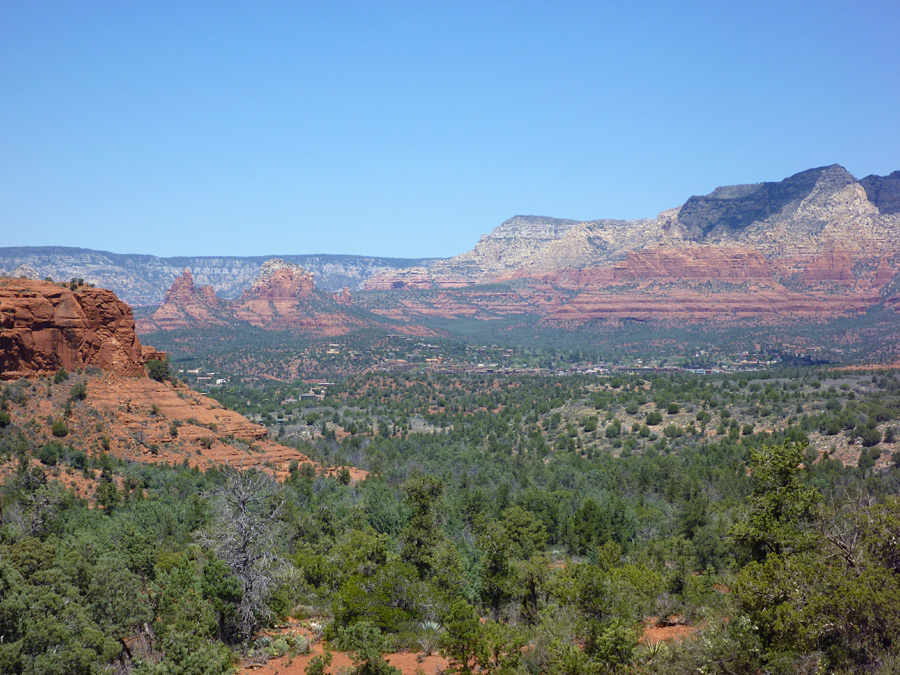
Known for its beautiful red sandstone formations, canyon walls, and pine forests, Sedona is a perfect city for hiking and enjoying nature.
Sedona is located in the Upper Sonoran Desert of northern Arizona. Its unique red-orange landscape is formed by the Schnebly Hill Formation, a layer of rock found only in the Sedona area.
Sedona offers so many beautiful hiking trails, ranging from casual strolls to strenuous climbs and everything in between. In this article we’ll cover 10 of the best hiking trails in Sedona.
Contents
1. Cathedral Rock

Cathedral Rock is a prevailing landmark of Sedona. It is an enormous rock formation reminiscent of a castle wall, and is one of the most photographed landmarks in all of Arizona due to its astounding beauty. In the light of the setting sun, the red rock almost seems to glow.
Cathedral Rock is 4 967 feet tall. As you can imagine, such an elevation results in some truly beautiful views of the surrounding Coconino National Forest and the unique landscape that belongs to Sedona.
Hiking Cathedral Rock is an in-and-out type of trail. The round trip is 1.4 miles, so it is quite a short hike and usually takes about an hour to complete. The constructed cairns will lead you along the path.
The accumulated gain of this trail is 750 feet. The trail is a mix of gentle incline and steepness. In the middle of the hike there is a near-vertical section that requires climbing, and towards the end, one last short scramble will bring you to the top of Cathedral Rock.
The views along the entirety of the hike are simply breathtaking, but reaching the very top and looking out at the scene is certainly the climax of this hike. The top is a wonderful spot to take a rest, admire the scenery and even watch some wildlife.

This trail hugs the east side of the mountain, so it is preferable to take this hike in the afternoon so that you’re shaded from the sun.
Dogs are allowed on this trail, provided they are on a leash. Keep in mind, however, that there are some steep sections that could be difficult for some dogs.
Address: 500 Back O Beyond Road, Sedona, AZ 86336
Website: http://www.sedonahikingtrails.com/cathedral-rock-trail.htm
Difficulty: Medium
2. Broken Arrow Trail
This simple yet beautiful trail is painless and easily accessible. You won’t find it too taxing, but you will still be rewarded with stunning views.

The beautiful red and white rock formations of Munds Mountain Wilderness are the main attraction of this hike, as well as the juniper, pine and cypress trees.
The trailhead elevation is 4 250 feet and the accumulated gain is 600 feet. The trail is wide, well-maintained and easy to follow.

On your way along the trail you’ll encounter a 90-foot deep sink hole sectioned off by wire (so you don’t fall in). This sink hole is called “Devil’s Dining Room”, and was first observed to collapse in 1880 when it sent up a diabolical cloud of dust, earning its name.

The Broken Arrow Trail eventually comes to a fork leading either to Chicken Point or Submarine Rock. Both are wonderful options to take, and you can even try both paths one after the other.
Chicken Point is a wide, flat area elevated above Submarine Rock, giving a view of the valley below. It’s a perfect spot to take a rest and maybe have a picnic!
Submarine Rock is a nice downward hike through a wooded trail lined with black volcanic rock to a view of Submarine Rock above.
This trail is well-loved for mountain biking. It is also used for a popular pink jeep tour, so you might see ones of these jeeps maneuvering up the rocky trail.
The hike is about 3.5 miles round trip and is accessible all year round.
Address: 799 Morgan Road, Sedona, AZ 86336
Website: http://www.sedonahikingtrails.com/broken-arrow-trail.htm
Difficulty: Easy
3. West Fork of Oak Creek
Oak Creek Canyon is a river gorge that runs between Sedona and Flagstaff. Often called the little cousin of the Grand Canyon due to its remarkable beauty, it is one of the most popular tourist destinations in Arizona, second only to the Grand Canyon. This is undoubtedly one of the most alluring and serene hiking trails in Sedona.

The gorge is about 12 miles long and the depth ranges from 800 to 2 000 feet. Oak Creek, a clear, meandering creek, flows along the bottom of the canyon. Be prepared to walk through water at times during this hike.
West Fork of Oak Creek is a soothing and peaceful hike. It goes three miles each way, but you can choose to make the hike shorter if you want.
The trail hugs along the crystal water, winding along the twists and turns and is sheltered by many trees and the canyon walls.
You can hike this trail at any time of the year – each season is beautiful and has its own charms. In spring, migrating birds flitter through branches above.
The forest awakens with wildlife in the summer months. As autumn arrives, the trees turn red and gold, lighting up the forest with a warm glow. In winter, icicles hang from the rocks and snow hides in the shade.
Camping is also an option here. Campsites are available 6 miles up the canyon.
Address: W Fork Trail, Sedona, AZ 86336
Website: https://www.fs.usda.gov/recarea/coconino/recarea/?recid=55432
Difficulty: Easy
4. Doe Mountain Trail
Nestled between Cockscomb and Bear Mountain, Doe Mountain is a 400-foot high mesa that offers beautiful views from the uniquely flat platform that rests above the desert valleys below.

This in-and-out trail starts off with a steady but gradual climb to the top of the mesa. Long, easy switchbacks will take you upwards. The accumulated gain is 500 feet.
Once you reach the flat top of this hill, you have many options for exploring. The paths on the top are much less clear to follow. But this creates a great opportunity to wander freely across the mesa top, finding new views and solitude from other hikers.
Walking to one of the edges of the mesa is fun and exhilarating, because the drop down is quite steep, and you feel quite removed from the rest of the valley below.
The mesa gives you a stunning panoramic view of the countryside, and you’ll be able to spot some landmarks as well, such as Bear, Maroon, and Wilson mountains, and Chimney Rock.
The trail is 0.7 miles to the top of the mesa, and another 1.3 miles around the edge of the mesa, but depending on how much exploring you do at the top, you can make this trip a big longer.
This trail is beautiful all year round. It is an easy and enjoyable trail, perfect for days when you want to do some walking but you don’t want to tucker yourself out.
Address: Boynton Pass Road, Sedona, AZ 86336
Website:https://www.fs.usda.gov/recarea/coconino/recreation/natureviewing/recarea/?recid=55296&actid=50
Difficulty: Easy
5. Boynton Canyon Trail
Boynton Canyon Trail has so much beauty to bestow on its hikers. This hike truly has it all – rock formations and ledges, canyon walls, lush forest, and even seasonal waterfalls. This trail also contains an energy vortex.

For those who don’t know, energy vortexes are thought to be centres of energy from the earth that are beneficial to the body, mind and spirit.
The city of Sedona itself is thought to be an energy vortex, because it is said that there are forces that emanate from the red rocks in this area, but there are a few areas in particular where the energy flows more profoundly – Boynton Canyon is one such area.
It is believed that these areas are rejuvenating – people often feel uplifted or refreshed when they visit an energy vortex.
This energy vortex is found near the beginning of the trail. But whether or not you believe in the mystical powers of these vortexes, the beauty alone is enough to rejuvenate anyone who visits this trail.
There are stunning views all along the trail. Indian ruins are also hidden in this canyon, so if you explore a little you may see some.
This in-and-out trail is 6.1 miles and has an accumulated gain of 898 feet. Most of the hike is in the sun, but there are some pines near the end. The final stretch climbs upwards, and at the top you are presented with a wonderful view back down the canyon.
There is also a resort near this trail, and which is an ideal spot to grab something to eat before or after your hike.
Address: Boynton Canyon Road, Sedona, AZ 86336
Website: http://www.sedonahikingtrails.com/boynton-canyon-trail.htm
Difficulty: Medium
6. Devil’s Bridge Trail
This trail leads to Sedona’s famed sandstone arch – it is the oldest and tallest arch in Sedona, and gives a beautiful view of the red rocks and deep green forests below.

There are a couple options for hiking up to this interesting arch. The first is a 4-mile out-and-back hike, most of which is flat and wide. Near the end of this trail there is a steeper climb up to the arch.
You can also start at Chuckwagon trailhead instead for a slightly shorter hike.
The hike offers wonderful scenery as you hike. When you come to a fork in the road, you can go left to the bottom of the arch and look up at it from below.

If you go right, you’ll be taken up a natural rock staircase to the top of the arch.
Once you reach the arch, you can walk out onto it! If you are afraid of heights then you might opt out of this, but it is safe and strong enough to support hikers.
Devil’s Bridge Trail is fun and enjoyable, with beautiful views of the interesting arch and the surrounding landscape.
This trail is quite popular and is often busy with other hikers, jeeps and mountain bikers.
Address: Dry Creek Road, Sedona, AZ 86336
Website: https://www.fs.usda.gov/recarea/coconino/recreation/recarea/?recid=55292&actid=50
Difficulty: Easy
7. Bear Mountain Trail
There are no bears on Bear Mountain – rather, the name comes from the shape of the mountain peak, which slightly resembles a bear.

Bear Mountain is a heart-pounding, exhilarating trail for serious hikers in search of a more difficult hike. This trail isn’t for everyone.
The 4.3-mile trail gains an impressive 1 975 feet, but for all this work you will be rewarded with stunning 360-degree views of snow-covered San Francisco peaks, Doe Mountain, and Courthouse Butte once at the top.
The trailhead is located at the same parking lot as Doe Mountain trail (a trail mentioned earlier in this list).
A wide dirt path begins this trail, dropping in and out of two shallow washes. But don’t let this fool you – this is only a warm up and after about 10 minutes the trail begins to climb and it doesn’t stop!
There are many false summits along the way. Many areas require scrambling up steep rock and using both hands and feet. There are also some natural rock staircases to traverse.
This trail is mostly in the sun and there is no water along the trail, so it is crucial to bring water, sunscreen and a brimmed hat. You will likely also want to bring snacks and energy drinks.
The round trip will take you 4-5 hours, depending on your speed. Take your time if you need to. You could easily spend all day if you wanted to, stopping to take pictures and to enjoy the nonstop views along the entirety of this incredible hike.

If you don’t feel experienced enough for this trail, wait until you do. Hikers have had to be rescued from this trail in the past, so make sure you know what you’re taking on if you choose to do this trail!
Address: Boynton Pass Road, AZ 86336
Website: https://www.arizonahighways.com/explore/hiking/bear-mountain-trail
https://www.fs.usda.gov/recarea/coconino/recarea/?recid=55222
Difficulty: Difficult
8. Airport Mesa Trail
This is a gorgeous looping trail that circles the upper slope of Airport Mesa (Table Top Mountain). High above the valley, you’ll be able to catch some stunning views, such as Mogollon Rim, Highway 179, and West Sedona.

The total distance of this hike is 3.5 miles and the accumulated gain is about 500 feet. There is little shade on this hike, so the best time to take on this trail may be in cooler seasons such as fall and winter.
At the start of the trail you’ll also find the Airport Outlook Trail. A short walk up this trail will bring you to the outlook, which is also the site of another one of Sedona’s energy vortexes. So, if you feel like recharging before or after your hike, make a pitstop here!
The main trail starts off by following a level path on the southeast side of the mesa with beautiful views of Oak Creek Valley. From here there are gradual ups and downs. The final stretch is a climb eastward, and you end up on Airport Road across from the starting point.
The scenery ranges from red rock to grey chalk to cacti, and the views are simply remarkable. This is a lovely trail to try.
Address: 483 Airport Road, Sedona, AZ 86336
Website: https://www.fs.usda.gov/recarea/coconino/recarea/?recid=71905
Difficulty: Easy
9. Courthouse Butte Loop

Stunning views of Courthouse Butte, Bell Rock, red sandstone slopes and wildflowers are just a few of the sights you will see on this wonderful trail.
This is a moderate walk – the loop is 3.9 miles and the accumulated gain is around 300 feet. The roundtrip is about 2 and a half hours.
The Courthouse Butte Loop is popular with tourists, but you will likely find some solitude as you keep hiking, especially when you pass the Bell Rock area where many tourists gather.
As you continue along the hike you enter Munds Mountain Wilderness. Trees and rolling contours of red rock will take your breath away. You will also get a great view of the monumental Courthouse Butte.
The trail is open year-round but is busiest in summer. If you’re looking to avoid tourists, it may be best to go from fall to spring.
Address: Off of Highway 179, Sedona, AZ 86336
Website: https://www.fs.usda.gov/recarea/coconino/recarea/?recid=72016
Difficulty: Easy/Medium
10. Fay Canyon
This easy trail is beautiful and fun for everyone. It is relatively flat which makes it a fun, leisurely hike and perfect for families with children, but the scenery is still gorgeous.
One of the best things about this trail is that, unlike many of the other trails listed here, it is mostly shaded from the sun due to the high canyon walls and lush trees.
Large oak and juniper trees surround this trail and their foliage provides ample coverage from the sun, especially through late spring to early fall when their leaves are out.

This is an in-and-out type of trail and is 2.4 miles in total, which means that it takes about an hour and a half to hike the whole thing. It’s the perfect trip for an afternoon.
The accumulated gain is a mere 155 feet – the trail is really quite level most of the way.
The trail is beautiful – the grand red rocks of the canyon walls rise above the path. If you watch the rock wall on the right side of the path (the north side) you’ll see Fay Canyon Arch. You will also spot some pretty desert plans on your way.
The trail ends at a towering rock formation and a sign that lets you know you’ve reached the end of the official trail, but if you want to keep exploring, you can wander up the rocks to view the canyon from an even better angle.
For a fun, beautiful and memorable hike, this is a great choice.
Address: Boynton Pass Road, Sedona, AZ 86336
Website: https://www.fs.usda.gov/recarea/coconino/recarea/?recid=54974
Difficulty: Easy
Conclusion
Sedona is a remarkable city that features so many stunning landscapes – from mountains to canyons to forests, you will find yourself marvelling at the astounding beauty of this place!
The vibrant red rock of the landscape is truly an impressive feature, as well as the energy vortexes, wildlife, cacti, and towering rock formations.
In this article we’ve listed ten of the best and most popular trails in Sedona, but this vast city has so much to offer, so don’t be afraid to explore the wilderness and discover new places!