
Having gotten our trail shoes warmed up with the tour of Southern California’s best trails, we decided to see what the north had to offer- and we weren’t disappointed!
Some of these trails have both easy and hard options within the same area, so you can pick just how hard you want to make it!
Do check with the relevant parks for opening information, as some of these walks may be affected by the summer fires of 2018.
Contents
- 1 The Harder Route: WHISKEYTOWN WATERFALLS (FOUR WATERFALLS)
- 2 ABOUT THIS TRAIL
- 3 The Easier Route: CRYSTAL CREEK FALLS
- 4 ABOUT THIS TRAIL
- 5 The ‘Easier’ Route: YOSEMITE FALLS (COLUMBIA ROCK)
- 6 ABOUT THIS TRAIL
- 7 The Harder Route: TOP OF YOSEMITE FALLS
- 8 ABOUT THIS TRAIL
- 9 GLEN ALPINE FALLS LAKE TAHOE
- 10 ABOUT THIS TRAIL
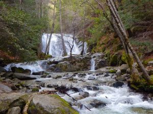
The Harder Route: WHISKEYTOWN WATERFALLS (FOUR WATERFALLS)

- LOCATION: Whiskeytown National Recreation Area, California.
- DISTANCE: Nine miles+
- TIME: 5 hours.
- ELEVATION: Various
- LEVEL: Moderately difficult.
- DANGERS: Not ADA accessible.
- OPEN TO: Hikers, both human and canine on leads (check precise areas).
- TERRAIN: Four waterfalls.
- ADDITIONAL INFORMATION: Bring water to drink. At the time of writing the park is closed due to fire.
ABOUT THIS TRAIL
Dust down your trail boots and be prepared to stomp like your life depends on it.
This first trail is not for the fainthearted and described as a “challenge”, which should give you some idea as to its difficulty level.
The five hours is only a suggested time, it might take you longer than that to fully take in all nine miles and four waterfalls. And there is some testing terrain along the way!
The four falls that this trail takes in are the Lower Brandy Creek, Lower Crystal Creek, Whiskeytown Falls and Boulder Creek.

Lower Brandy Creek has five beautiful falls that plunge down into the canyon. This is a moderately hard patch of the trail and takes in some highly pretty Indian Rhubarb – the best time to see this in flower is the early spring.
The Lower Crystal Creek Falls part of this trail is covered separately below and is considered easier walking than some of the other parts of the trail.
The Whiskeytown Falls is 220 feet tall and has a stairway going up it, bringing you face to face with the waterfall! Take care and hold on tight!
Boulder Creek Falls are not exactly easy strolling and will challenge you with its poison oaks, as well as difficult terrain – but the 138 feet high falls will be worth it!
Check out this great video showing a virtual tour of the Whiskeytown Waterfalls trails courtesy of Renae Tolbert.
Visit: https://www.nps.gov/whis/planyourvisit/waterfalls-of-whiskeytown.htm
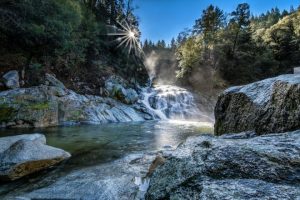
The Easier Route: CRYSTAL CREEK FALLS
- LOCATION: Whiskeytown National Recreation Area, California.
- DISTANCE: 1 mile.
- LEVEL: Fairly easy.
- OPEN TO: Hikers, both human and canine, on leads (check precise areas).
- TERRAIN: Waterfalls.
- ADDITIONAL INFORMATION: Suitable for families, smaller children ADA accessible. Manmade waterfall. Bring water to drink. At the time of writing the park is closed due to fire.
ABOUT THIS TRAIL

If you aren’t quite up for the four falls challenge and want something easier, then the Crystal Creek Falls is the one to opt for.
This is the walk to take all the family on and is the only one which can be considered accessible for anyone with a walking impediment.
This is the only “manmade” waterfall in the park – but could you tell if you didn’t know it?
Watch this great video showing off the natural beauty of Crystal Creek Falls by MJColeman100.
Visit: https://superiorhiking.com/crystal-falls/
The ‘Easier’ Route: YOSEMITE FALLS (COLUMBIA ROCK)
- LOCATION: Columbia Rock, Yosemite National Park, California.
- DISTANCE: Two miles
- TIME: 2-3 hours.
- ELEVATION: 1000 ft
- LEVEL: Moderately difficult.
- DANGERS: Not ADA accessible. Rocky terrain. Risk of injury. Take water. No shade during middle of day.
- TERRAIN: Waterfalls. Steep rocky climb. Don’t go off the footpath.
- ADDITIONAL INFORMATION: No dogs.
ABOUT THIS TRAIL
Although we have prefixed this trail as being the easier of the two options, it is not exactly a cakewalk.
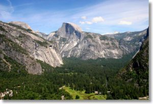
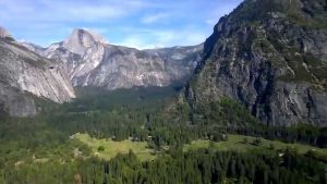
Both these walks are part of the Yosemite Falls Trail. This takes in the tallest waterfall in North America – so if you are only going to do one waterfall trail, we reckon this is the one to pick!
Take care when you are at the top though, it’s pretty high up and could be slippery.
This is still quite a tough trail and involves going up the mile-long, thousand feet path to Columbia Rock.
You’ll be glad you did though!
Take a look at this scenic video taken at Columbia Rock by Brian Thomas Clark.
Visit: https://www.alltrails.com/trail/us/california/columbia-rock-trail
The Harder Route: TOP OF YOSEMITE FALLS

- LOCATION: Yosemite Falls, Yosemite National Park, California.
- DISTANCE: 7.2 miles
- TIME: 6-10 hours.
- ELEVATION: 2700 ft
- LEVEL: Very difficult.
- DANGERS: Not ADA accessible. Rocky terrain. Risk of injury. Take water. No shade during middle of day. Do not swim in the creek.
- TERRAIN: Waterfalls. Steep rocky climb. Dangerous drops.
- ADDITIONAL INFORMATION: No dogs or cycles. Bring water.
ABOUT THIS TRAIL

This is the highest waterfall in the National Park – precisely 2,245 feet. The upper falls are some of the world’s highest, in fact.
But if you want to do more than look at it from Columbia Rock, then you have to be prepared to trek the 7.2 miles to the top. Be warned, this is not going to be easy!
This will bring you up close to the Upper Yosemite Fall and gives great views of the Sierra mountains.
If you choose to, when you reach the peak of the trail, you can go on up to Yosemite Point. This is going to put an extra 1.6 miles onto your trail.
Or if you want to go even further, then turn west for Eagle Peak – this is nearly another six miles more walking.
Here’s a great video showing a beautiful overlook of the falls thanks to Mark Witte.
Visit: https://www.yosemitehikes.com/yosemite-valley/upper-yosemite-falls/upper-yosemite-falls.htm
GLEN ALPINE FALLS LAKE TAHOE

- LOCATION: Glen Alpine Falls, South Lake Tahoe, California.
- DISTANCE: 5.1 miles
- ELEVATION: 692 ft
- LEVEL: Moderate difficulty.
- DANGERS: Not ADA accessible.
- TERRAIN: Waterfalls. Steep rocky climb.
- ADDITIONAL INFORMATION: Dogs allowed on lead. Permit required. Best visited in spring.
ABOUT THIS TRAIL
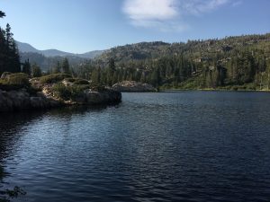
To round off our selection, we have a walk of middling difficulty.
This is situated in the South Lake Tahoe.
If you want to, bring Fido to accompany you on this trail – but make sure you keep him on a lead!
This is five miles of stunning scenery and crowned by the cascading waterfalls.
If you can’t walk far or are using a wheelchair, the falls can actually be seen from roadside.
The trail becomes less accessible if you want to leave the road and go to see grounds bordering the fall – as the surface is covered in gravel.
The Glen Alpine Falls are best visited in the springtime as the creek dries when the summer gets going!
Watch this epic video showing great views of Glen Alpine Falls from air and ground by ACwithFT.
Visit: https://www.yelp.ca/biz/lower-glen-alpine-falls-south-lake-tahoe
Any one of our five trails should be enough to warm the soles of your feet this summer.
Do check carefully with the National Park or area you are visiting for opening times and any further details.